

Location
CoLab, COM 100
Start Date
1-5-2025 5:30 PM
Document Type
Poster
Description
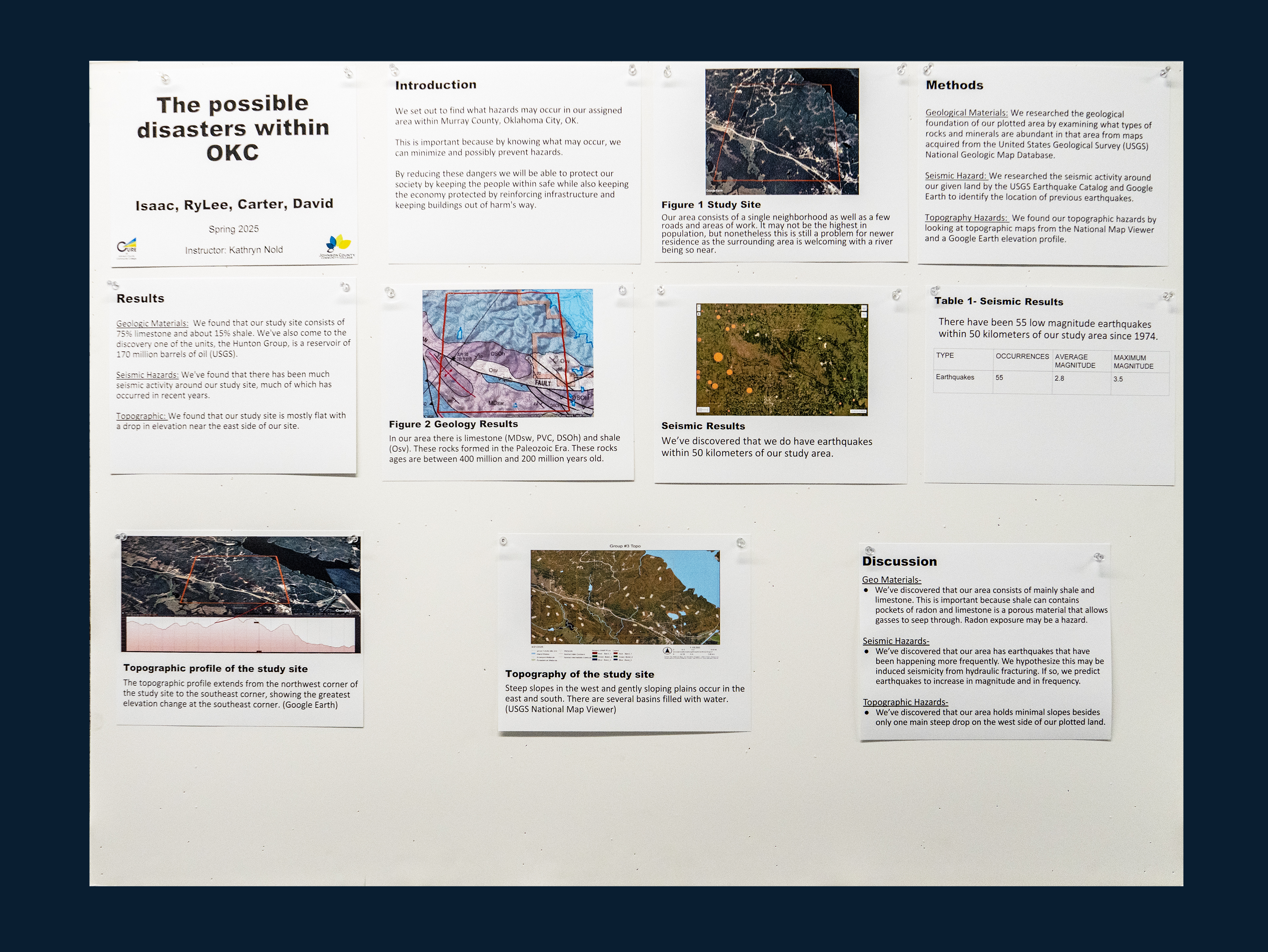
This study examines natural hazards that may impact future housing development in a 1-square-mile area located in Murray, Oklahoma. The goal is to identify potential geologic risks and inform residents and developers about land safety. We focus on analyzing geological materials, seismic history, and topographic features. The site’s geology includes shale and limestone, which may pose risks. For example, radon could lead to radon poisoning. We also reviewed seismic hazards by examining the region’s earthquake history. Since 1975, the area has experienced 57 earthquakes, with an average magnitude of 2.7 and a maximum magnitude of 3.5. This frequency and intensity suggest the area is prone to some seismic hazards, which may increase over time. Topographic features could also pose additional risks. These could exacerbate problems like flooding. By identifying geological, seismic, and topographic hazards, this research provides valuable insights to guide development decisions. We recommend implementing strategies like dams to mitigate these risks and ensure safer living environments for future residents. Understanding these hazards is essential for creating sustainable, safe housing developments in Murray, Oklahoma.
Image
The Possible Disasters Within OKC
CoLab, COM 100
This study examines natural hazards that may impact future housing development in a 1-square-mile area located in Murray, Oklahoma. The goal is to identify potential geologic risks and inform residents and developers about land safety. We focus on analyzing geological materials, seismic history, and topographic features. The site’s geology includes shale and limestone, which may pose risks. For example, radon could lead to radon poisoning. We also reviewed seismic hazards by examining the region’s earthquake history. Since 1975, the area has experienced 57 earthquakes, with an average magnitude of 2.7 and a maximum magnitude of 3.5. This frequency and intensity suggest the area is prone to some seismic hazards, which may increase over time. Topographic features could also pose additional risks. These could exacerbate problems like flooding. By identifying geological, seismic, and topographic hazards, this research provides valuable insights to guide development decisions. We recommend implementing strategies like dams to mitigate these risks and ensure safer living environments for future residents. Understanding these hazards is essential for creating sustainable, safe housing developments in Murray, Oklahoma.
Comments
The faculty mentor for this project was Kathryn Nold, Geosciences.